The Monarch of the Chochołowska Region
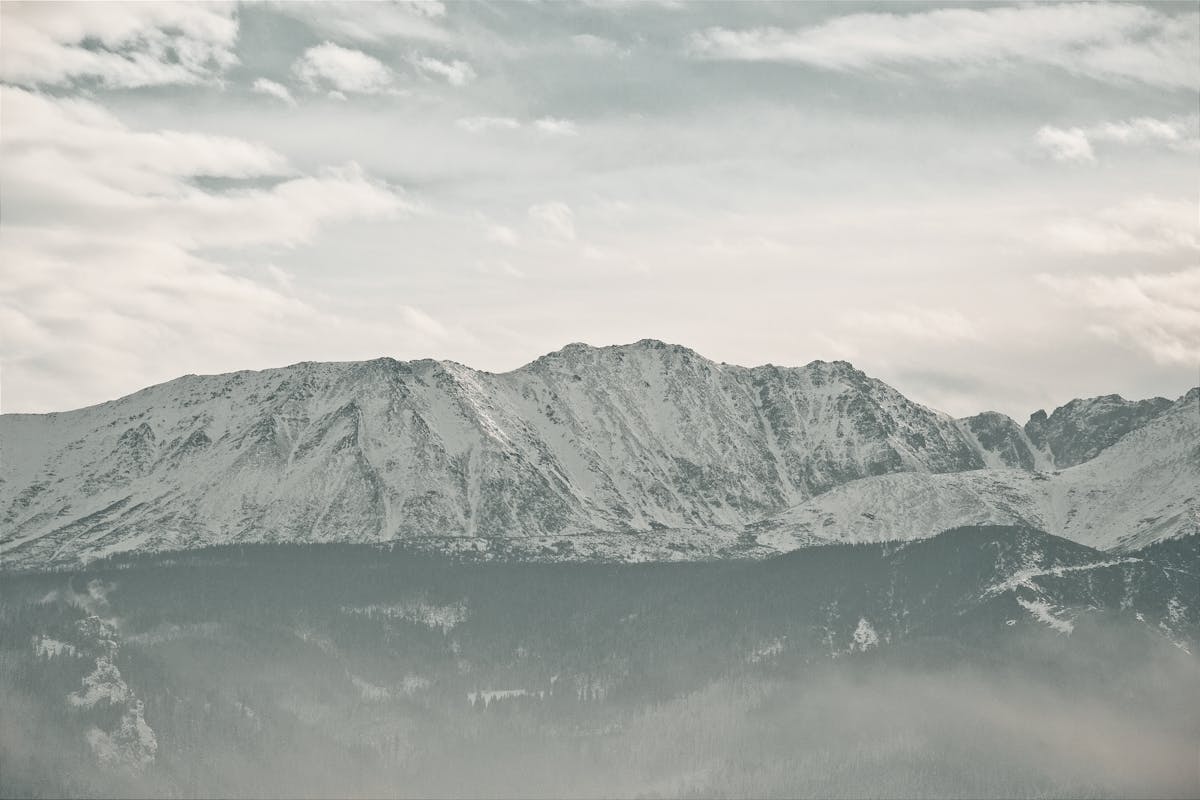
Standing at 2,064 meters, Wołowiec is the ultimate crown jewel of the Polish Western Tatras, a mountain that commands absolute respect and offers total 360-degree freedom.
Wołowiec is a powerful, pyramid-shaped peak that dominates the southern horizon of the Chochołowska Valley. It sits precisely at the intersection of three major alpine ridges: the main Tatra ridge forming the border with Slovakia, the ridge toward the Rohácze, and the ridge toward the Bobrowiec summit. Because of this unique position, it acts as a high-altitude "watchtower," providing views that extend deep into both the Polish and Slovak national parks.
1. History: The Boundary Between Worlds
Historically, Wołowiec has always been a boundary. Before the modern era of the Schengen Zone, this peak was a heavily monitored point on the border between the Austro-Hungarian Empire's Polish and Slovak territories. The name "Wołowiec" is linked to the historical grazing of oxen (*Woły*) in the lower meadows—a testament to the mountain’s hospitable, grassy slopes which allowed shepherds to bring their herds higher than in the jagged High Tatras. It was only in the early 20th century that it became a recognized destination for "high-altitude tourism," as hikers began to appreciate its symmetrical beauty and the incredible perspective it offers on the more dangerous Slovak peaks.
2. Geology: The Metamorphic Core
Unlike the limestone valleys below, the summit of Wołowiec is composed of **metamorphic crystalline rock**. This transition from sedimentary limestone to hard metamorphic rock is what gives the peak its endurance against erosion. The summit area is wide and relatively flat, a result of millions of years of wind erosion at high altitudes. This geological "spaciousness" is rare for a 2,000-meter peak and makes Wołowiec feel like a massive natural stadium, where you can sit and watch the clouds roll across the border without the "vertigo" common at Giewont or Rysy.
Wołowiec is a mountain for the patient traveler, offering immense privacy for spiritual reflection.
- Salah at the Zawracie Pass: Reaching the summit can be crowded on weekends. However, the **Zawracie Pass** (the saddle between Rakoń and Wołowiec) is covered in deep, clean alpine grass. It is often quiet and provides a protected, dignified space for Dhuhr and Asr prayers with a view of the Slovak Rohácze lakes.
- The 10-Hour Hydration Rule: This is a long, dry ridge. Once you leave the Chochołowska shelter, there are **no water sources** until you descend 6 hours later. We recommend performing Wudhu at the shelter and carrying a 500ml "emergency Wudhu bottle" in addition to your 3 liters of drinking water.
- Halal Energy Strategy: Use the "Bike Hack" mentioned in our prep tips to save your energy for the ridge. Conserving your physical strength allows you to maintain a better spiritual focus (Khushu) during your prayers at the high-altitude meadows.
3. The Panorama: Facing the Rohácze
The defining visual experience of Wołowiec is the view toward the west. You are confronted with the jagged, terrifying "dragon's spine" of the **Rohácze** peaks in Slovakia (*Roháče Ostry* and *Roháče Placzliwy*). These peaks are composed of different, much more fragile rock that creates a violent, serrated skyline. Standing on the relatively safe, grassy summit of Wołowiec while looking at the "Highlands of Terror" next door provides a powerful contrast between the mercy and the majesty of nature.
4. Wildlife: Guardians of the Border
Wołowiec is a territory for the **Tatra Marmot** (*Świstak*). They are often seen on the southern, Slovak-facing slopes where the sun hits first. You may also spot the **Alpine Accentor**, which seems to follow hikers along the ridge. In the rocky gullies below the peak, you may catch a glimpse of the **Alpine Newt** (*Traszka górska*) in the small, seasonal meltwater ponds—a rare and protected amphibian that survives at these extreme elevations.
For an unparalleled sense of majesty, tackle Wołowiec in early autumn (late September). The crowds are gone, the air is crisp, and the surrounding slopes turn a stunning golden-brown. But be prepared: the wind on the summit can be fierce. A solid windbreaker and a warm hat are absolute necessities, even if it feels warm in the valley below.
5. Navigation: The Grand Ridge Circuit
To experience Wołowiec correctly, we recommend the "Three-Peak Ridge Loop":
- Phase 1: Climb from the Chochołowska shelter to the peak of **Grześ** (1,653m).
- Phase 2: Walk the border ridge south toward **Rakoń** (1,879m). This section is treeless and offers continuous views.
- Phase 3: The final, steep climb to **Wołowiec** (2,064m).
- The Descent: Return via the green trail directly into the Wyżnia Chochołowska Valley—a fast but steep descent through high-altitude pine forests.
6. Safety: The Wind and the Ridge
The primary hazard on Wołowiec is not technical terrain, but the **wind**. Because the ridge is unprotected and stands at the intersection of three valleys, the wind can reach hurricane force even on sunny days. This can lead to rapid hypothermia or dizziness on the narrow sections. Always check the wind speed forecast before attempting the ridge, and never hesitate to descend if the gusts begin to push you off balance.