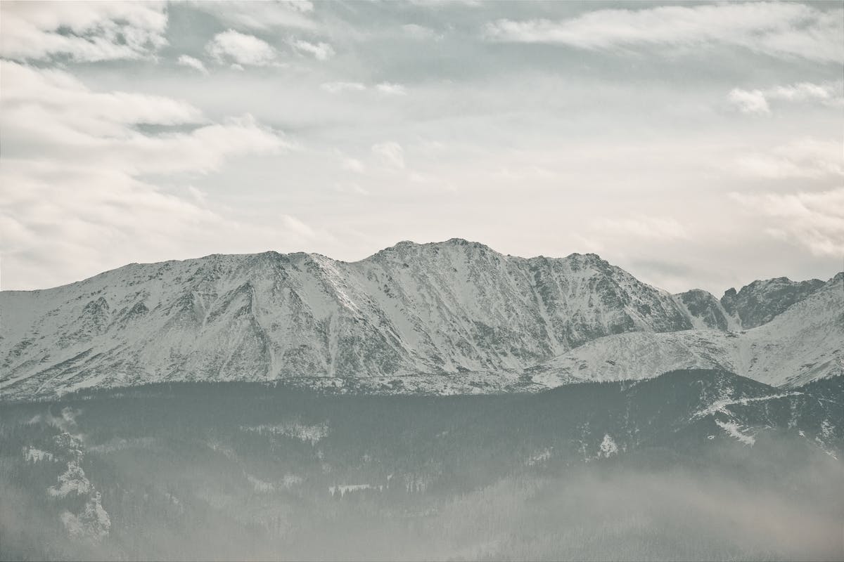
أكتاف ماووواتشنياك العريضة
ماووواتشنياك (2096م) المرساة المركزية لسلسلة القمم الحمراء. الوقوف في مركزه لا يشبه التوازن على جبل بقدر ما يشبه المشي عبر ملعب كرة قدم في السماء.
بحكم موقعه المركزي يوفر مناظر غير منقطعة في كل الاتجاهات: شمالاً تطل مباشرةً على الغابات الداكنة لوادي مالا لوكا، وجنوباً تهيمن أبراج الغرانيت المسننة للتاترا العالية السلوفاكية على الأفق.
١. ظاهرة "الحافة الحمراء"
القمم الحمراء تأخذ اسمها من نبات جبلي فريد يُدعى Sit skucina (Juncus trifidus). طوال الصيف يبقى أخضر، لكن أول صقيع خريفي في أواخر أغسطس يُطلق تغيراً كيميائياً: يتحول من أخضر نابض إلى قرمزي صدئ ثم نحاسي لامع. لأن ماووواتشنياك يمتلك أوسع هضبة عشبية بين القمم الأربع، هذا التأثير يبلغ ذروته الدرامية هنا. في "الساعة الذهبية" بعد الظهر يبدو الجبل بأسره وكأنه مشتعل — مشهد ألهم شعراء الغورال لقرون.
٢. الصعود: قناة كوبيلارز (السلاسل)
الوصول المباشر من الوادي يستلزم اجتياز القناة الشهيرة كوبيلارزوفي جليب (قناة كوبيلارز) عبر المسار الأزرق. في نحو ثلثَي الطريق يجب تسلق درجة صخرية عمودية بارتفاع 8 أمتار مجهزة بسلاسل فولاذية. الحجر الجيري مصقول كالزجاج من عقود مرور المشاة — حين يبتل يصبح زلقاً خطيراً. تحدٍّ حقيقي للأعصاب، لكن مكافأته — الظهور على الحافة الحمراء الواسعة — لا تُضاهى.
٣. أصداء تاريخية: دروب الرعاة العليا
هضبة ماووواتشنياك كانت تاريخياً من أعلى مراعي تاترا. الرعاة المحليون كانوا يسوقون أغنامهم عبر القنوات الشاهقة للتمتع بعشب Juncus الغني بالمغذيات. لا تزال "الرجال الحجرية" (الأكوام) مبعثرة خارج المسار — علامات قديمة استخدمها الرعاة لإيجاد طريقهم في الضباب. المشي هنا مشي عبر التاريخ الحي لمنطقة زاكوباني.
ماووواتشنياك يفرض عزلة تامة عن المرافق لمعظم اليوم — التحضر مفتاح النجاح.
- عطش الحجر الجيري: احمل 3 لترات ماء على الأقل. الصخر الجيري يمتص كل ماء المطر فوراً. لن تجد قطرة ماء صالحة للشرب بين قاع الوادي والقمة.
- سجادة الصلاة اللانهائية: الهضبة الشاسعة من أكثر الأماكن هدوءاً. امشِ 100 متر بعيداً عن المسار للحصول على عزلة تامة — موقع مثالي لصلاة الظهر أو العصر حيث الصوت الوحيد الريح وصرخة صقر بعيد.
- الملاحة في الضباب: إذا تدحرجت السحب لا تغادر المسار المحدد. الهضبة الواسعة تصبح سهلة للضياع في الضباب. ركّز على علامات المسار المرسومة على الصخور.
٤. الحياة البرية: نقار الجوز المنقط
أثناء صعودك راقب نقار الجوز المنقط (Orzechówka) — بستاني جبال تاترا. يدفن آلاف بذور الصنوبر الحجري للشتاء، والبذور المنسية تنبت شجيرات الجيل القادم. قرب القمة قد ترصد أيضاً طائر الجبل الصغير (Alpine Accentor) الذي يقفز نحو حذائك الجبلي بلا خوف ليتفحصك.
٥. تحت السطح: هاوية الثلج العظيمة
دون علم المشاة، هم يقفون فوق جاسكينيا فيلكا شنيزنا (الكهف الثلجي العظيم) — أطول وأعمق نظام كهوف في بولندا. الكتلة الجيرية الضخمة عبارة عن خلية نحل جوفاء عملاقة؛ أعمق نقطة معروفة تقع أكثر من 800 متر تحت القمة. معرفة هذا الظلام الشاسع تحت قدميك تضيف ثقلاً ميتافيزيقياً استثنائياً.
سلاسل قناة كوبيلارز قد تبدو مخيفة، لكن السر في الاقتراب: حين تصل إلى الحجر الجيري المصقول التزم بالجانب الأيمن من الجدار. توجد حواف "درج" طبيعية مخفية قرب الصخرة نادراً ما تكون زلقة — تجعل التسلق أسهل بنسبة 50%! وسبتمبر هو الوقت المثالي حين يتحول العشب إلى قرمزي نابض — تشعر حرفياً أنك تمشي على كوكب المريخ!